


lacs laouciens

sacadostcv
User
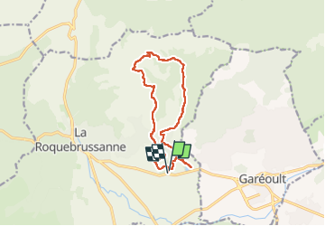

Length
13.2 km

Max alt
592 m

Uphill gradient
320 m
Km-Effort
17.5 km

Min alt
331 m

Downhill gradient
326 m
Boucle
Yes
Creation date :
2025-03-20 08:57:40.047
Updated on :
2025-03-20 14:33:13.925
4h35
Difficulty : Difficult

FREE GPS app for hiking
 SityTrail
IGN / Geographical institutes
SityTrail Plus
The world is yours!
About
Trail Walking of 13.2 km to be discovered at Provence-Alpes-Côte d'Azur, Var, La Roquebrussanne. This trail is proposed by sacadostcv.
Positioning
Country:
France
Region :
Provence-Alpes-Côte d'Azur
Department/Province :
Var
Municipality :
La Roquebrussanne
Location:
Unknown
Start:(Dec)
Start:(UTM)
257599 ; 4801968 (32T) N.
Comments